Below are RSS satellite
temperatures for various regions in Australia/Pacific. In a previous post (here) I
derived lower tropospheric temp for Australia in a rectangle shown in the map
below.

In this post I define a smaller
rectangle (red) to avoid any ocean areas, between longitudes 123.75 E to 146.25 E and
latitudes 31.25 South to 21.25 South.
All area inside & including the rectangle is summed & averaged. The data starts
Dec 1978 and ends Feb 2016. The actual measured area can
extend a little outside the rectangle to a maximum of 2.5/2 degrees, which is
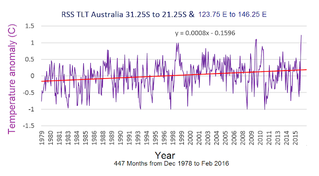
why I've drawn the rectangles smaller than the target area to avoid overlap. The resulting temperature graph is below:
It shows a very slight uptrend of 0.07C per century. Nothing like the official (specially homogenised) graph provided by Bureau of
Meteorology which shows a lot more warming the last few years (in line with their global
warming theory).

For comparison here is my graph again with a 16-point moving average and the Steven
Goddard graph of Australia temps (from here) which ends a couple of years
earlier:

The .nc file is from here:
↳
You have to register since Dec 2016 to download
stuff from RSS. If you just want the above file I've uploaded it here:
This sort of .nc (NetCDF) file can be opened
by mathematics programs like Matlab. The code has changed a bit between
revisions 2015a and 2016a. In the last post using r2015a I used function nansum to sum
values for a given area such as Australia. In r2016a nansum is replaced by
tsnansum which stands for time-series not-a-number sum.
Here is the code to open the file
in Matlab 2016a (more details here). Let us define a matrix a1.
Now you have a 144 x 72 x 458
matrix which is long x lat x months. Let us find the time series for one
location, Sydney, Australia. Sydney's longitude & latitude is 151E 33.8S. Unfortunately the grid resolution is quite course so individual cities can only be approximated. Using my conversion table (see bottom of post here) the nearest grid point is long = 133, lat = 23.
Sydney. Syd = squeeze(a1(133,23,:)
Temp anomaly (C):
Melbourne (this grid square is displaced quite a bit). Mel = squeeze(a1(130,22,:))
Tasmania. Tas = squeeze(a1(131,19,:))
Queenland:
Qld = squeeze(tsnansum(a1(128:132,:,:)))
Qld2 = squeeze(tsnansum(Qld(25:29,:)))'
Qld3 = Qld2/(5*5)
Northern Territory:
NT = squeeze(tsnansum(a1(124:128,:,:)))
NT2 = (squeeze(tsnansum(NT(25:29,:))))'
NT3 = NT2/(5*6)
Perth. Perth = squeeze(a1(119,24,:))
Mawson Station Antarctica. Maw = squeeze(a1(98,9,:))
New Zealand. Area centred on Taupo, North Island. NZ = squeeze(a1(143,21,:))
Nauru Pacific island near equator. Grid point is just east of it. Nauru = squeeze(a1(140,36,:))
Notice how much lower the temperature variation at this equatorial Pacific location is compared to the others. Equatorial ocean regions, especially the Pacific, act like air conditioners for the earth perhaps moreso than the frigid poles, by emitting EMR to space and losing heat by evaporation.
Canterbury South Island New Zealand. Cant = squeeze(a1(141,19,:))
Western Australia:
WA = squeeze(tsnansum(a1(119:124,:,:)))
WA2 = squeeze(tsnansum(WA(24:28,:)))'
WA3 = WA2/(5*6)
=================
Sundry points:
Title of data file is:
'Monthly anomalies of brightness
temperatures in the Lower Troposphere on a 2.5 degree grid'
Main variable description:
"Global monthly anomaly of
Lower Tropospheric temperatures derived from microwave radiometers on NOAA and
NASA polar orbiting satellites. The anomalies are deviations from 1979-1998
mean."
There are 144 points of longitude
& 72 of latitude. The points bunch up as they get closer to the poles.
There is no data within ~ 10 - 20 degrees of the poles due to the orbits of the satellites.
The complete header of the RSS TLT
.nc file is in a text file here.


Your blog provided us with valuable information to work with. Each & every tips of your post are awesome. Thanks a lot for sharing. Keep blogging.
ReplyDeleteSatellite
Planetary Vision: Rss Satellite Temperature For Australia/Pacific >>>>> Download Now
Delete>>>>> Download Full
Planetary Vision: Rss Satellite Temperature For Australia/Pacific >>>>> Download LINK
>>>>> Download Now
Planetary Vision: Rss Satellite Temperature For Australia/Pacific >>>>> Download Full
>>>>> Download LINK Nw
Thanks for a very interesting blog. What else may I get that kind of info written in such a perfect approach? I’ve a undertaking that I am simply now operating on, and I have been at the look out for such info. temperature chamber,
ReplyDeleteCan I just now say what relief to get one who truly knows what theyre talking about on the internet. You actually discover how to bring a worry to light and earn it crucial. Lots more people need to see this and understand this side in the story. I cant think youre no more popular since you absolutely develop the gift.Air conditioning companies near me
ReplyDeleteYou're the best to share us about this redesign. Trust you won't get tired on making posts as enlightening as this.
ReplyDeletelake nona florida air conditioning repair
I went to this website, and I believe that you have a plenty of excellent information, I have saved your site to my bookmarks. TV Wall Mounting Leeds
ReplyDeletePlanetary Vision: Rss Satellite Temperature For Australia/Pacific >>>>> Download Now
ReplyDelete>>>>> Download Full
Planetary Vision: Rss Satellite Temperature For Australia/Pacific >>>>> Download LINK
>>>>> Download Now
Planetary Vision: Rss Satellite Temperature For Australia/Pacific >>>>> Download Full
>>>>> Download LINK PM